
ESA CCI HRLC project successfully kicked-off for Phase-2
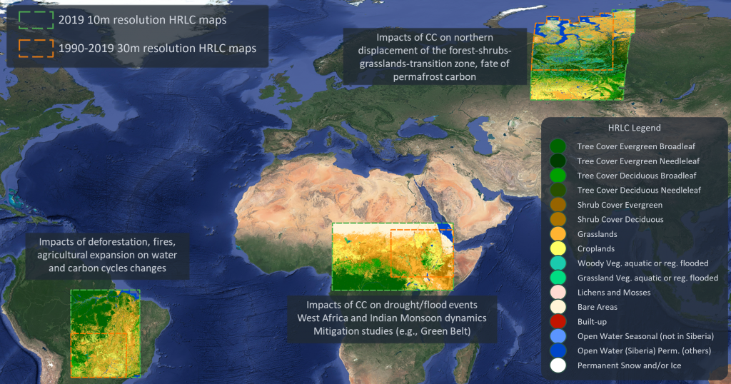
The High Resolution Land Cover (HRLC) Essential Climate Variable (ECV) project developed under the Climate Change Initiative (CCI) of ESA started the Phase-2 activities with the Kick-off in ESA ESRIN, Frascati, Italy. RSLab leads the project that involves 11 international partners. In Phase-1 the team produced land-cover maps at 10m resolution of 2019 and time series of land-cover maps at 30m resolution every 5 years between 1990 and 2019 in regions located in Amazon, Africa Sahel and Siberia (see figure below). Yearly based land-cover-change maps have also been generated. These products will be presented in the next weeks (stay tuned).
More about the project:
The main goal of the HR Land Cover ECV project is to study in detail the role of the spatial resolution in the mapping of land cover and land cover changes to support climate modelling research. Accurate land cover mapping and land cover change detection are extremely important for a better understanding of the global climate system. Land cover and related changes are in fact both cause and consequence of climate change either when the change is human-induced or generated from natural events. This has been widely recognized by the scientific community and demonstrated by the previous phase of the CCI programme, focused on the generation of Medium Resolution (MR) land cover maps at global scale. Differently from the MR land cover CCI, which provided annual land cover maps at 300m resolution covering the period 1992-2015, the HRLC project aims at producing maps characterized by a spatial resolution of 10m/30m. Moving from 300m to 30m requires the definition of new data analysis and processing methods, reframing the perspective with respect to the MR project both from the theoretical and the operational view points.